A map of my home town
Here’s a fun piece I did back in 2018 of an artistic map of Vancouver’s False Creek seawall. I really enjoyed playing around with ink for the first time. I was hoping to create a spilled-coffee look and I think I found it. Watered down, slowly building up layer upon layer, Winsor and Newton’s Peat Brown Ink did the trick.

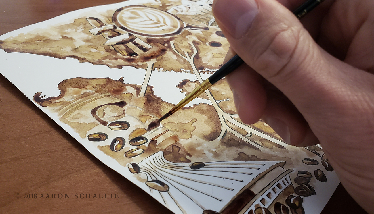
Seldom am I found not holding a coffee when I’m out trekking around the city or sitting and drawing on a trail somewhere, so coffee was definitely my inspiration. I’ve even tried painting with coffee.. with some success. The problem with coffee is when it dries, the layers of coffee wipe away unless you spray fixatif or something to seal it. This unfortunately makes things messy and start to run, so I’m glad I found an ink solution.


I was already well into this piece when I happened to come across a Facebook post from Spacing.ca Magazine. Based in Toronto, Spacing is a magazine and website that covers urbanist topics including art, culture, transit, city planning and governance, to name a few. The post was an announcement of their annual Creative Mapping contest and they were looking for artists to submit original creative maps inspired by a Canadian city. The deadline was fast approaching, but I figured I could finish in time.

The painting consists of a map of the False Creek seawall and all three bridges that cross it into downtown. From left to right they are; the Burrard Street Bridge; the Granville Street Bridge; and the Cambie Street Bridge.
Around the painting I included a few of my favourite pieces of public art and iconic buildings in the area. Starting at the top, a latte from any number of the overpriced Yaletown beaneries. To its left, the Inukshuk that stands at Sunset Beach and was the inspiration for Vancouver’s 2010 Winter Olympics logo.


To the right of the latte, stand the majestic North Shore mountains and the Lions peaks. Below that, BC Place Stadium, home of the Vancouver Whitecaps FC and the BC Lions Football team, with its new retractable roof. To the right of the mountains, container cranes at the Port of Vancouver, visible from this part of town, as they tower over Chinatown and Vancouver’s Strathcona neighbourhood.

Below the cranes is the Telus World of Science, a geodesic dome built in time for Expo 86 and home to Vancouver’s own Science World ever since. Below that, more coffee porn in a to-go cup.


The next image is of an Aquabus, one of the many tiny passenger ferries that ply the sheltered waters of False Creek. Standing tall next to the bridge on Granville Island, GIANTS at the Ocean Concrete worksite. Brazilian street artists Os Gemeos were commissioned to paint these monoliths for Vancouver’s 2014 Biennale exhibition.

On the left side of the painting, in the Kits Point neighbourhood, I included the H.R. MacMillan Planetarium. A beautiful building housing the Museum of Vancouver and the space centre. It opened it’s doors to the public in 1968 and was made to resemble a traditional Haida cedar-woven hat.


Finally, the totem pole that stood at the foot of Cypress Street in front of the Vancouver Maritime Museum at Hayden Park. The pole was carved by Mungo Martin with his son David and nephew Henry Hunt to mark the province’s colonial history. Oh yeah, and I framed it all with some coffee beans.

It took me a little over a week to complete.. and yes, my painting was published in the Summer 2018 issue ????

– Aaron